For the best experienceDownload the Mobile App


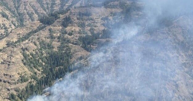
Paradise Fire prompting Level 1 evacuations in Oregon, over 1,600 acres
Published on: 08/05/2026
This news was posted by Oregon Today News


Description
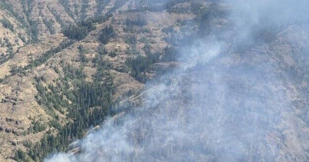
PARADISE FIRE (FIRE ORIGIN: AREA OF PARADISE CREEK & MILL CREEK WATERSHED, WALLA WALLA CO., WA)Acreage - 1,664Containment - 0%LEVEL 2 (BE SET) EVACUATIONS - • The region immediately north of Paradise Ridge
• Land near the southern boundary of the Level 1 zone, extending toward active fire
points
• Areas along Mill Creek that lie adjacent to active fire detectionsLEVEL 1 (BE READY) EVACUATIONS - Biscuit Ridge Road corridor, including surrounding forested areasBlack Snake RidgeGreen Ridge and adjacent drainagesPortions of Lewis Peak RoadAreas surrounding Thompson RoadLand stretching west toward Laird Gulch and Blue CreekUMC-1406043-C, UMC 1406043-DRoad Closures - • Mccown Road at US Highway 12 to Wilson Hollow Road and including the following
roads:
• Coppei Road
• South Fork Coppei Road
• North Fork Coppei Road
• Leid Road
• Lewis Peak Road at US Highway 12 to the end of the road and including the following
roads:
• Clancy Road
• Dent Road
• Mud Creek Road at US Highway 12 to Lewis Peak Road.
• Biscuit Ridge Road at Third Street (Dixie) to end of the road.
• Blacksnake Ridge Road at Tracy / Blue Creek / Spring Creek Intersection to end of the
road.Update (8/5/26 @ 4:15 p.m.)Level 1 (Get Ready) evacuations have been issued for some areas within Umatilla County in Oregon. The evacuation zones are visible online. People in the area should begin preparing to leave if conditions worsen.Update (8/5/26 @ 7:45 a.m.)The Paradise Fire is now 1,664 acres and 0% contained, per the National Interagency Fire Center.Update (8/4/26 @ 4:45 p.m.)The Paradise Fire is now 1,572 acres and 0% contained, per the National Interagency Fire Center.Original Story (8/4/26 @ 12:45 p.m.)WALLA WALLA CO., Wash. – There are now evacuations for the Paradise Fire burning at the conjunction of Walla Walla, Wallowa, Columbia, and Umatilla counties. The fire started back on July 16th in the area of Paradise Creek and the Mill Creek watershed in Walla Walla County. The fire has been consistently growing since then, now at 1,505 acres and 0% containment. Here are the new evacuations and road closures, per the Walla Walla County Emergency Management:"LEVEL 2 (BE SET) EVACUATION - • The region immediately north of Paradise Ridge
• Land near the southern boundary of the Level 1 zone, extending toward active fire
points
• Areas along Mill Creek that lie adjacent to active fire detectionsLEVEL 1 (BE READY) EVACUATION - • Biscuit Ridge Road corridor, including surrounding forested areas
• Black Snake Ridge
• Green Ridge and adjacent drainages
• Portions of Lewis Peak Road
• Areas surrounding Thompson Road
• Land stretching west toward Laird Gulch and Blue CreekRoad Closures - • Mccown Road at US Highway 12 to Wilson Hollow Road and including the following
roads:
• Coppei Road
• South Fork Coppei Road
• North Fork Coppei Road
• Leid Road
• Lewis Peak Road at US Highway 12 to the end of the road and including the following
roads:
• Clancy Road
• Dent Road
• Mud Creek Road at US Highway 12 to Lewis Peak Road.
• Biscuit Ridge Road at Third Street (Dixie) to end of the road.
• Blacksnake Ridge Road at Tracy / Blue Creek / Spring Creek Intersection to end of the
road."For more information about firefighting efforts of this fire, go to the Paradise Fire Official Information Facebook Page.COPYRIGHT 2026 BY APPLE VALLEY NEWS NOW. ALL RIGHTS RESERVED. THIS MATERIAL MAY NOT BE PUBLISHED, BROADCAST, REWRITTEN OR REDISTRIBUTED.
Other Related News

08/05/2026
The City of Eugene announced Wednesday that the Eugene Clean Energy Fund has qualified for...
08/05/2026
On a short week Oregon football has to face a Michigan State team on Nov 20 that while li...
08/05/2026
St Tropez the French Riviera fishing town turned celebrity hideaway is the latest vacation...
08/05/2026
As the Grasshopper fire burns across Mount Hood National Forest Portland General Electric ...
08/05/2026
After more than six decades visitors returned for one last walk through a place many say h...

Follow

Download Our App


Copyright 2022 © EPUERTO. All Rights Reserved